


Geotab Drive
4.3528.00 Reviews
App Specs
- Version
- 6.9.3
- Updated On
- License
- Free
- Downloads
- 500,000+
- Developer
- Geotab Inc
- Categories
- Maps & Navigation
- Platform
- Android, iOS
Screenshots
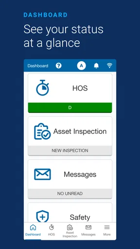
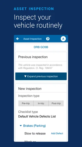
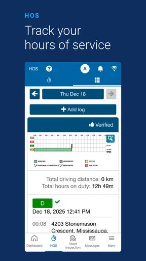
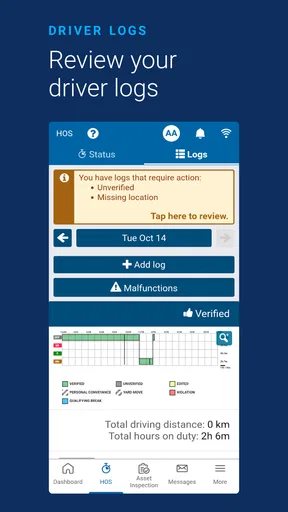
 Analysis by AppCompare
Geotab Drive is a mobile app for drivers and teams that use a compatible GO device to handle compliance-related work from a phone. I approached it less like a general navigation tool and more like a work companion: its value depends on the connected Geotab setup around it, the driver’s routine, and the quality of the mobile connection at the moment an important task needs to be completed. That distinction matters before downloading it, because this is not simply an alternative to Google Maps or Apple Maps.
Developed by Geotab Inc, the app sits in the Maps & Navigation category and is available free of charge. It is rated for Everyone, has passed the half-million-install mark, and holds an average rating of 4.3 from roughly 1.8 thousand ratings. Those figures suggest that it has found a real audience among professional drivers and fleet users, but they do not change the central question: does it fit the way you work on the road?
How Geotab Drive feels when the connection is part of the workflow
My first impression is that the app makes the most sense when it is treated as one piece of a larger compliance process. The GO device supplies the connected vehicle context, while the phone gives the driver a practical screen for interacting with that workflow. In other words, the app is not at its strongest when opened casually by someone looking for a destination. It is aimed at people who need their driving activity and work records to stay aligned with an established fleet system.
That connected design shapes nearly every useful moment. Starting a work session, reviewing a status, or completing a compliance-related action is more meaningful when the vehicle and driver are already associated correctly. A casual navigation app can often be opened, searched, and used with little preparation. Geotab Drive rewards preparation instead: the right vehicle, account, and device relationship need to be in place before the trip becomes busy.
This is one of the app’s less obvious strengths. It can reduce the need to keep separate notes about driving activity and then reconcile them later. For a driver moving between stops, that can be more useful than another map view. The trade-off is that the experience is less self-contained than a standard navigation app. Its usefulness depends on the surrounding Geotab environment rather than on the phone alone.
What happens during an ordinary workday
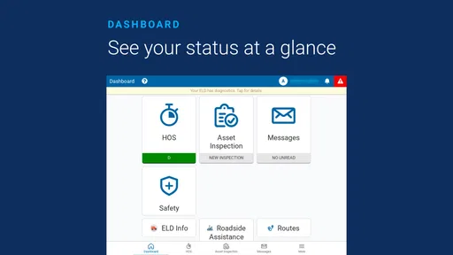
Imagine a delivery driver beginning a morning route. The phone is mounted, the vehicle is associated with the correct work setup, and the driver checks the app before leaving. In that situation, Geotab Drive can act as a central place for the driver-facing part of the compliance routine. The benefit is not flashy; it is the possibility of keeping required actions close to the actual driving day instead of postponing everything until the end of a shift.
The same workflow becomes more demanding when the driver is interrupted. A fuel stop, a vehicle change, a break, or a change in duty status can turn a simple sequence into a series of small decisions. I would not recommend trying to learn those steps while pulling away from a loading area. The sensible approach is to become familiar with the app while parked and to agree on a consistent routine with the fleet manager.
Worth Reading Before You Choose

EA SPORTS FC Mobile 26 Is a Bigger Football Game, but It Takes Time

Flipboard Shows What News Apps Must Do Beyond the Feed

Switching to Android Auto Means Rethinking Your Driving Routine

Google Calendar Makes a Crowded Week Easier to Manage

Ludo King Makes the Most of the Minutes Between Plans

Baby Panda World Brings Quick Play to Modern Phones, but Its Game Library Feels Busy
A useful habit is to check the app before the vehicle starts moving, not after a warning or discrepancy appears. That early check gives the driver a chance to notice an account or vehicle mismatch while there is still time to correct it safely. It also makes connectivity problems easier to identify before they affect an active trip. This is a practical advantage that a short store summary will not tell you.
Why mobile context matters more than a desk review
Geotab Drive is designed for a setting where attention is limited. A driver may be standing beside a vehicle, sitting in a cab, or dealing with paperwork after a long route. That makes clarity and timing more important than having a large collection of options. The phone format is convenient because it travels with the driver, but it also creates pressure: small screens, gloves, poor lighting, and rushed stops can all make an otherwise straightforward action feel slower.
I would mount the phone securely and arrange the workflow so that interaction happens while parked. That is not merely a safety preference. It also reduces mistakes caused by trying to interpret a status while navigating traffic or handling a delivery. The app’s real value comes from supporting the workday without becoming another distraction inside it.
Drivers who use several vehicles should pay particular attention to the handoff between one vehicle and another. A phone can make switching convenient, but convenience can also encourage assumptions. Before moving, confirm that the active vehicle and driver context are correct. This is especially important in shared-fleet situations, where a device may remain in a cab after the previous driver has finished.
For supervisors, the mobile setting creates a different consideration. A process that seems obvious in an office may be awkward in rain, at a crowded depot, or during a rushed loading window. Training should therefore use realistic situations rather than only explaining menu names. Practice a vehicle change, a delayed connection, and a correction while parked. Those exercises reveal friction much earlier than a policy document does.
Connectivity: the moments when patience matters
The app’s relationship with connectivity deserves careful attention. Because it works with a GO device and supports compliance needs, the quality of the connection can affect how confidently a driver knows that an action has been registered or that current information is available. I would not treat a weak signal as a minor inconvenience when the task relates to a work record.
In a strong connection area, the experience should feel more natural: the driver can use the phone as part of an ongoing connected workflow rather than wondering whether an update has reached the fleet system. In a poor coverage area, the important issue is not just whether a screen loads. It is whether the driver understands the current state and knows what to do next without creating duplicate entries or abandoning a required step.
That leads to a simple rule: do not repeatedly tap an action just because the response is slow. First look for a visible change in status, then give the connection time to catch up. Repeating an action can make troubleshooting harder, particularly if the first attempt eventually succeeds. When the vehicle is parked, note what happened and follow the company’s correction process instead of improvising a second record.
Another useful tip is to separate connection troubleshooting from driving decisions. If the app appears delayed at a depot, stop in a safe place and check the phone’s connection and the vehicle context before continuing. If the same issue happens repeatedly in one route area, report the pattern to the fleet administrator rather than assuming that every delay is a driver mistake. A recurring location-specific problem deserves a process response, not repeated tapping.
Failure and recovery without making the problem worse
No connected mobile workflow should be judged only by its best-case operation. The more revealing test is what happens when the phone, vehicle device, account, or network does not behave as expected. Geotab Drive is most useful when the organization around it has a clear recovery procedure. The app alone cannot replace that procedure.
If the phone loses connection, I would keep the vehicle parked while checking the obvious basics: is the correct vehicle selected, is the phone still signed in, and is the GO device present and operating as expected? Those checks sound simple, but they prevent a common mistake—treating every problem as a network failure when the actual issue is an incorrect vehicle or driver context.
If a driver has already moved on and notices a discrepancy, the safest response is to follow the fleet’s established correction method at the next safe opportunity. Avoid trying to repair a record while driving. Also avoid creating a second entry merely to make the screen look complete. In compliance-focused software, a transparent correction is generally more useful than a confusing sequence of guesses, even if the correction takes a little longer.
Fleet managers should define what drivers should do when the app cannot be used normally. That guidance might include who to contact, what information to record, and when the driver may continue. I am deliberately emphasizing the process because this is where many connected tools succeed or fail in practice. A good app is helpful, but a good recovery plan keeps a temporary technical issue from becoming a stressful roadside decision.
There is also a human failure mode: fatigue. After a long day, a driver may rush through a status change or forget which vehicle was active. A short pre-trip check and a consistent end-of-shift routine are more valuable than expecting perfect memory. The app can support that discipline, but it cannot supply it automatically.
Using mobile data thoughtfully
People often ask whether a work app will consume a lot of mobile data. The honest answer is that usage depends on how the connected workflow is configured and how often the app communicates with the GO device and related services. I would not make a fixed data estimate from the app’s category or its download size. Instead, drivers should watch their phone’s system-level data usage during a normal workweek and compare it with their plan.
That check is easy to overlook when the app is free. Free to download does not mean that mobile connectivity has no cost, especially for drivers using a limited data plan or roaming between regions. If a company provides the phone, this is worth including in fleet onboarding so that data surprises do not appear after deployment.
There are sensible ways to be data-conscious without interfering with the job. Connect to trusted Wi-Fi for app maintenance when appropriate, keep the phone’s operating system and the application current according to company policy, and avoid using unrelated streaming or heavy downloads on the same connection during a shift. More importantly, do not disable necessary connectivity simply to save data if doing so undermines the compliance workflow.
The app’s current version is 6.9.3, and it requires Android 7.0 or later. That makes device planning important for organizations with older phones. Before rolling it out to a whole fleet, test the actual handset models, mounts, and network plans that drivers will use. A technically compatible phone may still be unpleasant if its battery, screen, or performance is poor in the vehicle.
Battery use deserves the same practical treatment. A phone running a work app throughout a shift is not just a personal device anymore. Keep reliable charging available, but do not route a cable where it can interfere with controls or visibility. A dead phone at the end of a route can complicate the same records the app was meant to organize.
Where it beats ordinary navigation apps—and where it does not
Compared with Google Maps, Apple Maps, or another everyday navigation app, Geotab Drive serves a narrower purpose. Those familiar alternatives are usually better for finding a destination, comparing routes, checking local places, and planning a personal journey. I would choose them when the main question is, “How do I get there?”
I would choose Geotab Drive when the main question is, “How do I keep the driver-facing part of this connected work process aligned with the vehicle and compliance requirements?” That is a different job. The app’s strength is its place inside a Geotab-equipped fleet, not its ability to replace every consumer map feature.
This distinction also explains who should skip it. A private driver who only wants turn-by-turn directions will probably find the surrounding setup unnecessary. A small business without a compatible GO device or a Geotab-based workflow may gain little from installing it in isolation. Likewise, someone seeking a fully independent navigation tool should start with a dedicated mapping app instead.
For a fleet already using Geotab hardware and processes, the calculation changes. Keeping the driver interaction on the phone can be more practical than asking people to manage separate paper notes, disconnected tools, and later reconciliation. The app is especially relevant when consistency across drivers matters more than having a broad consumer feature set.
Who will get the most from it
I see the best fit in professional driving environments where compliance actions need to happen close to the vehicle and where managers already understand the Geotab ecosystem. Drivers who regularly move between stops can benefit from having a dedicated work interface rather than relying on memory. Supervisors can also gain a clearer routine for onboarding, provided they teach the process around the app instead of treating installation as the whole deployment.
The app is less compelling for occasional users. If you drive only for personal errands, do not use a GO device, or have no fleet process to connect it to, the app’s purpose will feel distant from your needs. Installing it just because it is free is unlikely to produce a useful experience.
Before adopting it, I would ask four practical questions. Is the vehicle equipped with the compatible GO device? Does each driver know which account and vehicle context to use? Is there a safe, repeatable place to complete mobile actions? And does the organization have a recovery plan for weak connectivity or a device problem? If the answer to these questions is yes, the app has a much better chance of becoming part of the routine rather than another unused icon.
My connectivity verdict
Geotab Drive is a focused Maps & Navigation app whose real identity comes from its connection to the GO device and to a fleet’s compliance workflow. I like that it brings the driver-facing side of that work onto a device people already carry, and I think it can be genuinely useful when the surrounding setup is organized. Its strongest benefit is procedural: it can help place important actions nearer to the moment they happen.
My reservations are equally practical. The experience is not designed to stand alone like a consumer map, and connectivity, vehicle context, account setup, and training all affect how dependable it feels. Drivers need clear instructions for delays and corrections, while managers need to test real phones and real routes rather than assuming that installation equals readiness.
Geotab Drive is free, rated for Everyone, and maintained by Geotab Inc, with a current version of 6.9.3. I would recommend it to drivers and fleets already working with the compatible Geotab hardware and processes. I would skip it if what you really need is independent navigation or a general-purpose map. The right question is not whether the app can replace your usual map, but whether it can make your connected compliance routine easier to perform correctly.
Pros
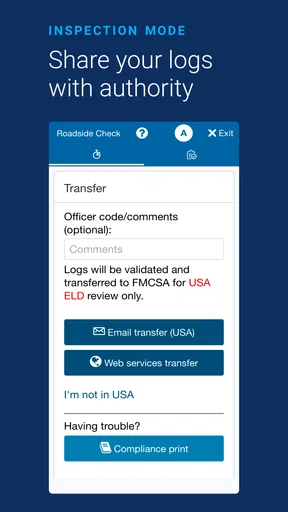
- Simplifies electronic logging and reduces manual paperwork for drivers.
- Supports vehicle inspections with clear
- guided workflows.
- Works with Geotab telematics for centralized fleet visibility.
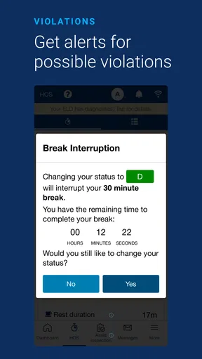
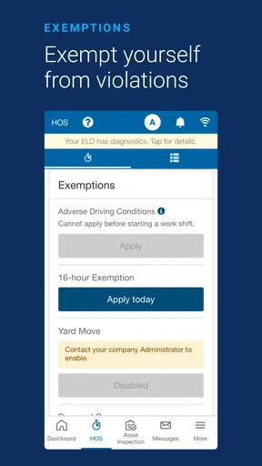
- Helps identify hours-of-service risks before they become violations.
- Provides useful records for audits
- compliance
- and fleet administration.
Cons
- Requires a compatible Geotab setup and fleet administrator account.
- Some features depend on stable connectivity and properly configured hardware.
- Frequent status updates can feel disruptive during busy routes.
- The interface may take time to learn for drivers new to ELD systems.
- Location and driving data collection may raise privacy concerns for some users.
FAQs for Geotab Drive
What is Geotab Drive used for?
Geotab Drive is a mobile application designed for commercial drivers who use the Geotab fleet management platform. It helps drivers record hours of service, complete electronic logging duties, perform vehicle inspections, submit forms, and manage work-related information from an Android or iOS device. Its available features can depend on the company’s Geotab configuration, local regulations, and the driver’s assigned permissions.
Does Geotab Drive automatically track my driving hours?
Geotab Drive can record driving activity when it is connected to a compatible Geotab telematics device and properly configured by the fleet administrator. The app may automatically change duty status based on vehicle movement, but drivers are still expected to review their logs, select the correct status, and make required edits or annotations. It should not be treated as a replacement for checking records carefully.
What do I need before I can log in to Geotab Drive?
You generally need an account created by your employer or fleet administrator, along with the correct login credentials and access to the company’s Geotab environment. The app may also require a compatible vehicle connection, location permissions, mobile data or Wi-Fi, and a supported Android or iOS version. If you cannot sign in, your fleet administrator is usually the right person to contact.
Can Geotab Drive be used without an internet connection?
Some information may remain available temporarily when the device has limited or no connectivity, but Geotab Drive is intended to synchronize records with the fleet system when a connection is available. Offline behavior can vary according to the app version, device settings, and company configuration. Drivers should reconnect as soon as possible and verify that logs, inspections, and submitted information have synchronized correctly.
Does Geotab Drive collect location or personal information?
Because Geotab Drive supports electronic logging and fleet operations, it may process information such as driving activity, vehicle data, duty status, inspection records, and location-related details. The exact data collected depends on the connected Geotab hardware and the employer’s configuration. Before using the app, drivers should review their company’s privacy policy, permissions, and applicable workplace or transportation regulations.


